

 During Covid-19
 About Us
 Your Saved Properties
Image:
Url:
#
Explore Text:
Explore
Full Description:
Southern - Living the true island life
To the outside eye, the village of Inarajan seems to have been untouched by the hand of change. It is known as the most distinctly Spanish-style village on the island, with the village proper on Inarajan Bay, remaining basically intact over the decades.
A visitor could drive through the small Spanish barrio-style streets, which until recently were one-way streets, and see the history of Inarajan in its old houses. The houses reflect a mixture of architecture influenced by the Spanish period and the early American period (the early 1900s).
The village retains many of its traditional ways, with the St. Joseph Church still at the center of many activities, including the village’s annual fiestas. Residents of the village are still a small number of families whose roots are deeply entwined in Inarajan. Very few outsiders have moved into the village, and very few modern structures have been erected.
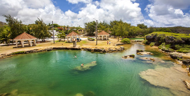
Part of what gives Inarajan its heritage-rich flavor is one of its more recent additions: the GefPa’go Cultural Village, which sits right on the bay. The village, which consists of ancient-style thatch-roofed huts, is staffed mainly by elder Chamorros who demonstrate traditional Chamorro arts, crafts and cooking to visitors.
UMATAC, Guam: Living around the bay provides breathtaking views every day.
The small village of Umatac is located in southern Guam along Umatac Bay. The community of Umatac is relatively smaller than others on Guam and made up of a handful of residents, many of whom are related to each other.
Interspersed between old houses that sit along the bay’s shoreline are ruins that have become prominent reminders of the Spanish colonial era in the village. Plaques are placed throughout the village that describes the Spanish era to visitors. Remains of the Spanish times include the former Spanish governor’s residence, the site of the old San Dionisio church and several Spanish forts and a battery.
A bumpy two-lane road runs through the center of the village, and visitors coming down into Umatac from the steep hills in the north will first notice stones placed into a hillside in the shape of the island of Guam, welcoming them to the village. A couple of small stores and the San Dionisio Church, built at its current location in 1939, sit along the road.
The road, with houses built in the first half of the last century, then opens up into a spectacular view of the bay before coming to a small park with a children’s playground built by IT&E in the 1990s. Adjacent to the park is the mayor’s office, right on the beach, with perhaps the best view of any mayor’s office on Guam.
At the center of the bay is an obelisk monument to Ferdinand Magellan’s landing in 1521, bearing the inscription, “Magellan landed here.” The bay is also home to some of the island’s best surfing.
MERIZO, GUAM: Between mountain and sea
Merizo skirts Guam’s scenic southern shoreline on a long strip of land between mountains and sea.
Cocos Lagoon, several miles square and enclosed by a large triangle of the reef, extends about three miles out from the village. Cocos Island Resort draws day visitors to the small, densely vegetated, low-lying strip of land along with the lagoon’s southern exposure. The lagoon is distinguished from the deeper water outside the reef by an array of vivid blues and greens that signify shallow water over sand flats and protected coral gardens. Mama’on Channel, the lagoon’s deep main pass, runs west to east past Merizo Pier and the village boat ramp, gradually shallowing as it cuts farther into the lagoon.
FiestanTasi (Festival of the Sea) is held annually in Merizo and celebrates the importance of the ocean to Guam’s past, present and future. It often includes boat races and other water sports competitions and exhibitions. Dates of the festival vary from year to year.
On the other side of the winding main coastal road, Route 4, several rivers flowing to the sea from the nearby mountains cut lush valleys through dry savanna foothills. Much of the population lives in these rural valleys, which are mainly residential areas dotted with a few farms and ranches, shadows of the community’s agrarian past.
YONA, GUAM: One of Guam’s largest municipalities, with a southern flavor
Yona is the first southern village on the eastern side of Guam. Its boundaries stretch for six miles, from the south side of Pago Bay to the north side of the bridge at Jeff's Pirates Cove in Ipan, Talofofo. The village also extends west on Route 17, or Cross Island Road, from Route 4, or ChalanKantonTasi, to Tarzan Falls, near the Naval Magazine, overlook.
Its jurisdiction also includes the area from Pulantat and Manenggon Valley to Lonfit Bridge in Chalan Pago. As such, Yona is one of Guam's largest municipalities in the area and is divided into ten sections: Baza Gardens, Windward Hills, Ylig, Manenggon, CampWitek, Pulantat, Triangle, Central Yona, Tagachang and As Namo.
TALOFOFO, GUAM: “God’s Country”
Former Mayor Tito Mantanona coined the name “God’s Country” for Talofofo, a nickname affectionately used by many residents and seen on signs throughout the village. At the heart of Talofofo is a four-way intersection recognized as the crossroads of this small village. Anyone giving directions to a location in this village inevitably starts with this intersection, which is also at the heart of economic activity in Talofofo, with three corner stores doing business near the four-way intersection. North from the intersection is the village’s Catholic church, San Miguel Church, as well as the mayor’s office and houses, most of them similar to homes in suburban communities.
East from the intersection is the Onward Talofofo Golf Course, after which the road intersects with Route 17, locally known as Cross Island Road.
West from the intersection are more houses and Talofofo Elementary School, a sports field, and the Talofofo gym.
South of the intersection is the Seventh-day Adventist Church and Notre Dame High School, and as the road heads downhill toward the Talofofosubcommunity of Ipan and Talofofo Bay, it passes the ancient Talofofo Caves.
Sitting below the hills of the main village is the coastal community of Ipan, Talofofo. A number of secluded beaches and a scattering of houses, along with a gas station, make up most of Ipan. The area also includes Ipan Beach Park, a popular spot for barbecues. Jeff’s Pirates Cove is located on the northern border of Ipan and has become an institution in the area. It is best known for its relaxed-atmosphere bar and grill, along with a small souvenir store and an outdoor area used for arts and craft fairs, concerts and other gatherings.
The southern boundary of Talofofo is marked by the Ugum River (joined by the Talofofo River), which flows into Talofofo Bay. But as the Talofofo Bay park facilities are on the southern side of the bay, the area most people visit in Talofofo Bay is actually part of the neighboring village, Inarajan.